By Julie Schlesselman, Local History & Genealogy Department Manager, FCPLD
This article ran in the July 3, 2024, edition of the Brookville American and is available in the book Forgotten Franklin County, volume 5.
For the Forgotten Franklin County column of August 19, 2020, I wrote about Beers the Cartographer. Mr. Beers’ map company is the primary reason that we have the wonderfully detailed 1882 Atlas of Franklin County.
Today’s article about the 1882 Atlas will be about just a few of the renderings within it. There are about 40 drawings all together. They include houses and occasionally occupants of the places as well as a few business structures. In past Forgotten Franklin County articles, I have already utilized many of these images.
What I found most interesting about the supplemental drawings was that typically to have added information about yourself or renderings of your family, house or business, the subscriber, as they were called, usually paid the book producer a small fee to have that information included. In the case of the 1882 Atlas,oddly, many of the renderings have very little historical or biographical information to accompany them. In my opinion, there’s not near enough written information that one would have anticipated to accompany such detailed images. Great renderings, not so great details.
Considering that much may have happened to some of these people or places after 1882, it occurred to me that maybe you would be interested in some additional facts and findings regarding a small sampling of the drawings.
Bath Township
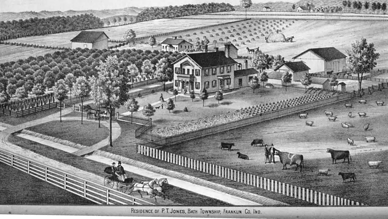
The P.T. Jones farm is depicted on page 72 of the Atlas.
Phillip Tenley Jones, a son of Abraham and Sarah Jones was born in Franklin County in 1820 – he started teaching school at age 19 and did so for 20 years. P.T. also did land survey work, was justice of the peace, and was a township trustee. He finally settled down on the west half of section 26 in Bath Township. In 1870 Jones built the handsome residence as seen in the drawing, and it was known across the region as one of the finest homes in Franklin County. It was located on the north side of Hetrick Rd., between Harmony and Springfield roads.
The Jones’ farm property remained in the Jones family until the 1990s and the house stood for just over a century. It was torn down in the 1980s.
I was told this was a beautiful house on the inside and its exterior was quite grand for the time. Before it was torn down, some folks went in and salvaged pieces of the interior woodwork, stairs, and a few fixtures. So, bits of this place still live on in other Franklin County buildings. This house had more than a few unique architectural characteristics and it’s probable that P.T. Jones had a hand in the overall design and layout of his grand home. It wasn’t uncommon in the 1800s to have an educated man design his own domicile.
Springfield Township
The Benjamin Smith farm, on page 63 of the Atlas, was located in section 5 of Springfield Township, at Liberty Pike and Whitcomb roads. It still stands but looks a little different than it did 140 years ago.
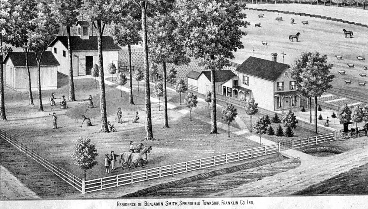
Benjamin Smith was a lifelong Franklin County resident and lived in the same area all of his life. He was born in this township in 1826. His father was Samuel Smith, who originally came to Springfield Township in 1814.
Benjamin’s obituary said through the industry and perseverance of his parents “out of the wild woods they opened up for cultivation a beautiful farm.” It’s difficult to imagine so much of what is now Franklin County farmland as woods and even wetlands – but the area here was much different when the earliest settlers arrived.
Benjamin seems to have always lived somewhere on the family farm as the Biographical and Genealogical History of our tri-county area says, “…he married and settled on the old homestead, and also rented from his father.” Benjamin had always been engaged in agricultural pursuits. After Benjamin’s father died and prior to his mother’s death, Benjamin bought out the interests of his siblings so he eventually owned the entire farm. “In 1881 he built on the same place, but at a different point. The new farmhouse is more on the up-to-date plan and his barns and other improvements are all first-class.”
It can be assumed Benjamin Smith wanted a rendering of his home in the 1882 Atlas because he did much to improve his family’s farm and it was a brand new, modern place that he wanted to showcase. If his parents cleared out woods to settle there, more than likely the house Benjamin grew up in was a large log home located elsewhere on the property.
Benjamin died in 1901.
Laurel Township
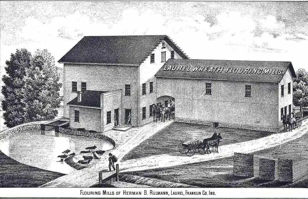
The image of the Laurel Wreath Flouring Mills appears on page 60 of the Atlas. Herman Bernard Rulmann, whose name has been spelled everyway in a variety of records, including Bullman, was born in Hanover, Germany in 1835. At age 14 Herman was apprenticed to a miller near his home in Germany where he worked about three years learning the trade of milling. Herman worked in different parts of Germany as a mill hand until 1865 when he immigrated to America. He landed in New York and worked there, then moved on to Pennsylvania. He then moved to Ohio where he worked in Dayton and Cincinnati. After he accumulated enough in savings, Herman purchased Frank Seavitt’s mill in Oldenburg, Franklin County, in 1871. Herman lived in Oldenburg for about 8 years until he purchased a mill in Laurel from Fisher & Withers. He moved to Laurel about 1879. At the time the 1882 Atlas was published Herman’s mill in Laurel was the largest grist mill in Franklin County. It was equipped with the most modern components available at the time, and Herman’s mill could produce 65 barrels of flour a day. Herman Rulmann produced flour under the name of the Laurel Wreath Mills, which was extremely well-known throughout the region.
It seems that the name, Laurel Wreath Mill was in use for many years and was associated with more than one location. In the writings of James Day, he states in 1843, “A man by the name of Sam Fisher removed and enlarged the mill known as Laurel Wreath Mills. It was moved 3 ½ miles south of town [Laurel].” Day goes on to say in 1868, “The Laurel Wreath Mill burned again. It was owned by James A. Dirbyshire.” Exactly when the Laurel Wreath Mill was moved to the outskirts of Laurel is unclear as it burned again in 1877. The partnership of Fisher & Withers is who rebuilt the large mill which Herman came to own and operate, so more than likely they are the ones who rebuilt it between 1878-79 in its new location.
The Laurel Wreath Mill no longer stands, but when Rulmann owned it, it was located approximately where Pearl Street turns into Laurel Road. It was propelled by the waters of the river and also utilized water from the cut-off of the canal.
It is unclear exactly how long Herman remained in Franklin County, but assumptions lead me to believe he left Franklin County sometime in the 1890s to live nearer his children, since he shows up in the 1900 census in Auglaize County, Ohio and is working as a grocer. Herman died in 1906, in Minster, Ohio.
Brookville Township
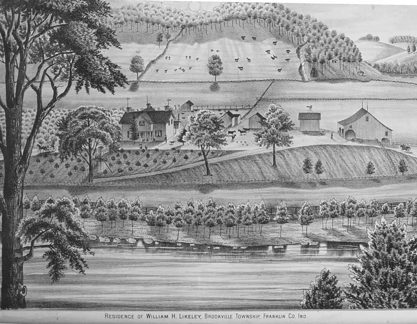
The William Likely farm showcased on page 50 in the Atlas seems to have been owned by both the senior and the junior Likely.
The Atlas claimed that Mr. Likely added to the original 80 acres entered by his father to make an excellent farm of 192 acres. It was one of the nicest in the county.
In October of 1897, William H. Likely sold at public auction his personal property, not only consisting of household and kitchen items, but farming implements, grains and bees. His farm was also going to be sold. According to the newspaper advertisements, “This farm consists of first-class bottom and good upland, is well improved and is one of the best grain and stock farms of its size in southeastern Indiana.”
The farm must not have sold at this auction for the price sought, as Likely didn’t actually sell it until 1902, to Dr. E.L. Patterson.
Local photographer Ben Winans photographed a similar view of the Likely farm approximately 20 years after it appeared in the atlas. The 1882 rendering gives more detail however, as by the time Winans took a photo of it, many evergreen trees planted around the house had grown significantly and hindered the view of it.
William Likely Jr. died in 1914 in Colorado. He moved out west to be with his children.
The Likely farm no longer stands. The area is now inundated by the Brookville Reservoir. Part of the farm was positioned very near where the dam itself is located.
One of the most interesting things I found when researching Mr. Likely was a vague reference to his pasture land in a story by Maurice Brackney, John LaRue, and Walter Winscott. The story was called “The McCarty Family Cemetery.”
In part it said, “When the first Franklin County death occurred in the McCarty family, a suitable flat acre or two of land was sought for final resting places….today the location is on the north side of the Whitcomb Pike almost exactly north of the school buildings…..By 1920 there were perhaps 15 grave stones still standing. The area itself was part of the creek pasture of the pioneer Likely farm.”
According to the men telling the story, “In 1920 this was an excellent place to hunt rabbits – briars grew among fallen stones and the bushes. Probably no person had set foot in the place with any concern for the dead in 75 years. It was a flat area knee-deep in grass and briars.”
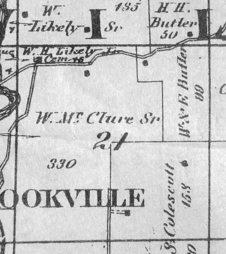
Without delving head-first into the local land deeds, the Bureau of Land Management website shows early land patents for the McCartys in this area, so it reasons the McCartys possibly held possession of this ground, and or surrounding ground, before Likely – or they were close neighbors.
The 1882 Atlas and subsequent maps don’t acknowledge any cemetery at the location remembered by the storytellers. Perhaps by the time the 1882 Atlas was being made, the cemetery had already become overgrown since there had been no burials there in years. Maybe the cartographers just couldn’t see it
Brackney, LaRue, and Winscott, the gentlemen telling the story about what they called the McCarty Cemetery claimed, “A few hours work with a team of horses and a chain and the stones were dragged to the edge of the creek bank. A few more hours and the grass and briars were all gone and the top soil exposed…..T’was easy then to plow, furrow and plant potatoes in this hallowed ground….”
Potatoes!!!???
That’s the perfect lead into my next story…..
NOTE: Documentation – albeit not good at all – exists from 1971 when the McCarty Cemetery was moved by the Corps of Engineers for the construction of the dam and reservoir. At that time, 27 interments were exhumed and moved. Twenty-five were unknown, and two were identified as Benjamin and Sarah McCarty. These burials were reinterred in the community section at the Sims-Brier Cemetery in Fairfield Township.
You must be logged in to post a comment.